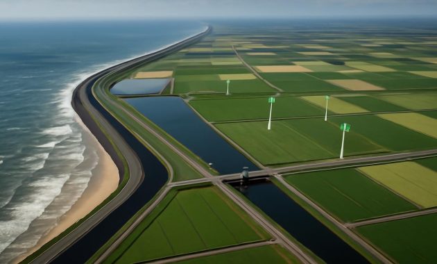
The morning I first saw a Dutch river flowing backward, the sky was the color of unpolished steel and the air smelled faintly of salt and wet clay. A cold wind came tunneling up the estuary, pushing ripples across the broad, engineered waterway in a way that felt almost unnatural—like watching a film being played in reverse. A barge moved slowly past, stacked neatly with concrete blocks, and on the distant horizon, cranes bent like long-legged birds over a raw, growing edge of land that, only a few years before, had simply not existed.
The Country That Redrew Its Own Outline
On most maps, the Netherlands looks fixed: a small, low rectangle tucked along the North Sea, rimmed with dikes and threaded with rivers. But those maps lie, or at least they lag behind reality. For more than a decade now, the Dutch have been quietly bending their rivers into new shapes—diverting entire flows, slicing new channels through farmland, and nudging estuaries into different paths. In doing so, they’ve reworked the coastline itself and pulled new land out of the sea like a magician revealing a final card.
This isn’t the loud kind of environmental engineering that makes headlines around the world. There are no glittering megastructures, no single grand dam to point to from space. Instead, it’s a series of deliberate, almost understated moves: a channel straightened here, a river mouth widened there, a barrier opened at just the right tide. It’s an orchestra of small interventions, timed and tuned to alter something enormous—the line where water ends and land begins.
Stand on one of the new coastal dunes and you can feel the scale of it beneath your boots. The sand underfoot was dredged from the seabed not long ago. The roads that now cross this infant landscape follow routes drawn on laptops in government offices years before any of this was solid, dry reality. What appears timeless is, in fact, brand new, crafted out of currents, sediment, and strategy.
The Long Memory of a Low Country
To understand why a modern country would dare to move its rivers, you have to remember that the Dutch have never accepted their geography as given. The Netherlands is, to a remarkable degree, a handmade nation. Its history is written not only in documents and archives, but in the neat right angles of polders, the raised ribs of dikes, and the ghostly outline of former coasts now lying kilometers inland.
For centuries, the Dutch fought what they called the “water wolf”—the relentless creep of the sea into soft, peaty land. Medieval villages built earthen mounds just to keep their houses above storm tides. Later, windmills pumped water out of lakes and marshes and into canals, draining what are now bustling towns and fertile fields. The country’s wealth was built on this defiance: more land meant more farming, more trade, more room for a growing population.
But the 20th century taught the Netherlands a new kind of humility. The North Sea flood of 1953 killed more than 1,800 people and drowned entire regions overnight. In response, the Dutch built the Delta Works—a vast system of dams, storm surge barriers, and reinforced dikes that became a symbol of human triumph over nature. For a time, it looked like the final answer. Concrete and steel, gates and sluices: the sea would be kept decisively outside the door.
Then climate change arrived on the horizon like a slow, dark swell. Sea levels began to creep upward; storms grew a little stronger, a little less predictable. The old equation—higher dikes, bigger walls—no longer felt sufficient. There was a dawning realization that eternal defense would be exhausting, expensive, and perhaps, in the long run, impossible. The country needed a new story to tell about water, one that didn’t hinge on permanent war.
Turning Rivers Sideways
The new story started not at the sea, but inland, along the main arteries that drain the European continent: the Rhine, the Meuse, and the smaller but no less vital rivers that braid through the Dutch landscape. These rivers had been tamed over generations—straightened for shipping, locked between high embankments, their floodplains pinched and colonized by towns, fields, and roads.
When climate scientists began to model heavier rainfall upstream—more water rushing down from Germany, Belgium, and France—it became clear that these confined rivers would need somewhere to go. Simply fortifying their banks would only pressurize the system further. So the Netherlands did something that, at first, sounded almost like heresy in such a densely populated country: it decided to give its rivers more space.
This idea took on a name—“Room for the River”—but it didn’t stay a neat policy slogan for long. It became a program of earth-moving and map-redrawing that would quietly transform the country’s relationship with water. More than 30 major projects unfolded along the big rivers, and with them came a radical set of choices.
In some places, entire bends were cut off, and new channels were carved straight across low-lying farmland. In others, dikes were deliberately set back, surrendering previously inhabited land to seasonal floods. New side channels were opened, turning single strands of water into branching braids that could spread and slow high flows. To make all this work, villages were moved, farmers bought out, roads rerouted. The human disruption was real, often painful, and yet there was a larger picture the country kept its eye on: if the rivers could breathe inland, the sea might be a little less deadly at the edge.
All of this river re-plumbing did something else, too. It changed the way sediment—sand, silt, and tiny flecks of ground-up mountain—moved through the system. Instead of racing unimpeded to the sea, those sediments began to be steered, slowed, concentrated, and sometimes trapped in particular places. And that’s where the coastline story begins to take shape.
Rewriting the Edge of the Sea
When rivers meet the sea, they don’t just bring water; they bring the raw material of land. Every grain of sand under a Dutch dune has traveled a long, broken path from far inland, carried by unseen currents and gravity’s gentle insistence. For decades, flood barriers and hard coastal defenses had interrupted that quiet process. Sediment that would once have fed the shore was diverted or lost to deep water. Erosion nibbled at the coast.
In the last fifteen years, the Dutch answer has been both bold and oddly soft. They began to think of sediment as a kind of currency, something that could be spent and invested rather than simply managed. If rivers were realigned inland, their load of sand could be better captured, channeled, and reused where it mattered most: at the line of surf and dune.
The most visible symbol of this is a sweeping landform locals have come to call the “sand engine” or “sand motor”—an artificial peninsula of roughly 21 million cubic meters of sand, pumped up from the seabed and sculpted into a giant hook jutting into the North Sea. Laid down along the coast, it was never meant to be permanent in its original shape. The idea was beautifully counterintuitive: instead of building fixed barriers and fighting erosion meter by meter, the country would dump a huge surplus of sand in one place and let waves, tides, and currents gradually spread it along the shore, thickening beaches and dunes over years.
Link that strategy to diverted rivers, and you glimpse the wider choreography. Upstream, channels steer more sediment toward estuaries. Downstream, engineered sandbanks and shallow zones coax that material into settling where it can be taken up by coastal currents. It’s a kind of quiet partnership with physics. The result: bulging foreshores, beaches marching seaward, and young dunes building height at a rate that outpaces the slow rise of the sea.
When you walk along one of these new stretches of coast, there are few signposts to tell you that the land under your feet is, in effect, a national adaptation strategy made visible. Children build sandcastles whose foundations rest on spreadsheets and hydraulic models. Dogs chase gulls along a beach that, fifteen years ago, was still open water. And just beyond the line of surf, buried pipelines and carefully placed shoals keep redistributing the river’s gift of sediment, turning an abstract climate risk into a living, reshaped shore.
Life on Borrowed Ground
Of course, the coast is not an empty canvas. People live here, and they’ve had to adjust to a landscape that is, in subtle ways, always under negotiation. In some places, that negotiation feels tense. A farmer whose family worked the same polder for generations now looks out over a broad new secondary channel where his best fields used to be. A street of riverside houses finds itself on a newly built island, accessible only by a slender bridge. Entire hamlets have been raised onto higher ground, their old sites turned into deliberate flood basins designed to soak up the river’s overflow.
Yet, alongside the losses, new things have emerged—landscapes that didn’t exist before this grand reshaping began. Fresh sandbanks have become nesting sites for terns and plovers. Where dikes were set back and floodplains reconnected, reed beds have rushed in, their papery stalks whispering in the wind and hosting bitterns, spoonbills, and dragonflies. Side channels swarm with juvenile fish in spring, safe from the fastest current.
You see it in the way people use these places. Cyclists follow new dike-top paths, tracing curves that are less about property lines and more about hydraulic logic. Canoeists slip into calm branches of re-routed rivers, paddling among half-drowned willow trunks and listening to the hush of water flowing where it once would have been blocked by a bank. Urban dwellers wander out on weekends to beaches that simply weren’t there when they were children, tiny dots moving across a fresh, bright apron of sand.
The paradox of this “borrowed” ground is that it’s both secure and contingent. It’s secured by some of the most advanced modeling, planning, and engineering on Earth. But it’s also explicitly designed to shift, erode, rebuild, and change in rhythm with the weather and the tides. The Dutch, long known for claiming land and then freezing it in place, are now learning to live on land that openly admits its own fluidity.
Numbers Beneath the Waves
Hidden below the sensory experience of wind, sand, and river smell is a dense layer of math and monitoring. Every grain of sand added to the coast, every meter of river embankment moved, has been tallied and tested. Behind the scenes, the last decade and change of river diversion and coastal reshaping reads like a long ledger of inputs and outcomes.
| Measure | Approximate Scale | Purpose |
|---|---|---|
| Major river realignments & side channels | 30+ projects across Rhine–Meuse basin | Increase flood capacity, steer sediment, reduce peak levels |
| Coastal sand nourishment (annual) | ~10–15 million m³ of sand added | Maintain and extend the coastline, offset sea-level rise |
| “Sand engine” mega-nourishment | 21 million m³ in one placement | Feed surrounding coasts over 15–20 years via natural forces |
| New or raised land | Tens of km of new or widened dunes & foreshore | Storm protection, space for housing, nature, recreation |
| Dike relocations inland | Hundreds of hectares returned to floodplain | Lower flood heights, create wetland habitats |
These are not static achievements; they are ongoing commitments. The diverted rivers must be watched. Channels silt up and need to be dredged or allowed to evolve. Sandbanks migrate, sometimes faster than models anticipated, sometimes slower. Engineers and ecologists move through these areas like gardeners in a vast, semi-wild estate—letting some things run, trimming back others, occasionally deciding that a certain experiment needs to be undone and rethought.
Still, the overall trend is unmistakable. If you compare detailed coastal maps from the early 2000s to those today, you see subtle but steady outward bulges, a thickening of the land’s edge. Places that once sat nervously close to the sea now have a wider buffer of beach and dune. The rivers, once crammed into narrow corridors, spread their wings across roomier floodplains designed to flood not as disasters, but as planned events.
The Quiet Radicalism of Letting Go
Perhaps the most radical thing about the Netherlands’ reshaped rivers and coastline is not the scale of earth moved, but the shift in mindset they represent. This is a country that once believed, sincerely and for good reason, that safety lay in ever higher, ever stronger barriers. Now, increasingly, safety is understood as a relationship with water that includes negotiation, compromise, and even a measure of surrender.
Diversions that send a river across a farmer’s ancestral field are hard decisions; so are plans that accept certain low meadows will flood every few winters. But these choices buy room for millions elsewhere. They reduce the pressure on dikes that protect cities, ports, and industrial heartlands. They allow the sea to express some of its force in soft, shifting sand rather than in catastrophic breaches.
From a distance, this can sound clean and strategic. Up close, it’s messy and emotional. People grieve for lost houses, for churches that once stood proudly on the old bank. Others find new meaning in watching spoonbills return to wetlands that were, not long ago, maize fields. Teenagers skateboard on smooth promenades fronting newly broadened beaches, half-aware, perhaps, that they are the first generation to grow up with this particular coastline as their normal.
What’s striking is how little of this grand experiment appears in the global imagination. The Netherlands is still often trotted out as an example of dikes and dams—a land of hard defenses and binary thinking: dry versus wet. But walk along a diverted river, feel the give of manufactured dunes under your feet, and you begin to realize that the country is quietly drafting a different kind of future. Not a fortress against rising seas, but a living hinge between land and water, flexible by design.
Somewhere out on a gray North Sea morning, a dredger’s intake hums as it swallows sand from the seabed, while inland, an excavator leans into a riverbank that has stood in the same place for generations. Between those two machines lies a web of intention that stretches from satellite imagery to fishermen’s stories, from hydrological models to the unmistakable, physical fact that the Netherlands is, once again, a slightly different shape than it was a decade ago.
Maps will catch up. They always do. But for now, the truest outline of this country lives in the restless join between river and sea—a place where water has been bent, persuaded, and partnered with, until it helps to build the very land it once threatened to erase.
FAQ
Has the Netherlands really diverted entire rivers?
The main river systems—the Rhine, Meuse, and their branches—haven’t been picked up and moved wholesale, but major sections have been rerouted, widened, and given new side channels. In hydraulic terms, this constitutes significant diversion: altering how and where water and sediment flow through the landscape, and ultimately how they reach the sea.
How does diverting rivers help reclaim land from the sea?
Diverted and redesigned river channels control where sediment is delivered and how quickly it moves. By steering more sand and silt toward specific estuaries and coastal zones, and combining that with large-scale sand nourishment, the Dutch effectively feed their coastline, allowing beaches and dunes to advance seawards and thicken against erosion and sea-level rise.
Is this different from traditional land reclamation with polders?
Yes. Classic Dutch land reclamation involved enclosing shallow seas or lakes with dikes and pumping them dry, creating fixed polders. The current approach relies more on working with natural processes—using sediment transport, tides, and waves to build and maintain flexible buffers of sand and wetland rather than rigid new blocks of low-lying, fully enclosed land.
What are the environmental impacts of these projects?
There are trade-offs. Some farmland and existing habitats are lost when dikes are moved or channels dug. However, new floodplains, wetlands, and dynamic coastal zones have created habitat for birds, fish, and plants. Many projects are designed with ecological goals in mind, so overall, much of the new landscape has higher biodiversity than what it replaced.
Can other countries copy the Dutch approach?
Elements of it can be adapted—especially the idea of giving rivers more space and using soft, sediment-based coastal defenses. But every delta and coastline has its own geology, politics, and culture. What the Netherlands mainly offers is not a template, but a mindset: treating water as a partner in shaping the land, rather than an enemy to be blocked at all costs.